Wyaconda Township Map and General Information
Wyaconda Township Map
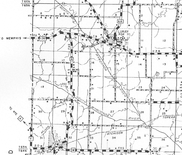
Wyaconda Township is made up of Section 1 through 36 in Township 65 North Range 9 West for a total of 36 square miles.
Wyaconda Township General Information
Cemeteries
| Cemetery Name |
Latitude D.d |
Longitude D.d |
Section |
Note #: |
| Blattner Cemetery |
40.401389N |
-091.915000W |
T65N R9W-32 |
|
| Butler Cemetery |
|
|
T65N R9W-04 |
1 |
| Cemetery on the Dave Brown Farm |
|
|
T65N R9W-23 |
2 |
| Cemetery on the Walter Clough Farm |
|
|
T65N R9W-36 |
3 |
| Combs Cemetery |
40.450556N |
-091.891667W |
T65N R9W-09 |
|
| Eldorado Cemetery |
|
|
T65N R9W-10 |
4a |
| McCoy Family Cemetery |
|
|
T65N R9W-14 |
5 |
| Wyaconda Cemetery |
40.389722N |
-091.926944W |
T65N R9W-32 |
|
| Zimmerman Cemetery |
40.451667N |
-091.873333W |
T65N R9W-10 |
4b |
| Note #: |
Who, What, Where |
| 1 |
"The cemetery is on State road K, North of Luray. This was the first Cemetery of Luray but in later years, many graves were moved to Combs Cemetery" Page 374 "Cemetery Inscriptions of Clark County, Missouri," Compiled by Wilma Dunlap and Wilma Walker. I could not find this Cemetery listed by U. S. Geological Survey. |
| 2 |
page 374 "Cemetery Inscriptions of Clark County, Missouri," Compiled by Wilma Dunlap and Wilma Walker. I could not find this Cemetery listed by U. S. Geological Survey. |
| 3 |
page 377 "Cemetery Inscriptions of Clark County, Missouri," Compiled by Wilma Dunlap and Wilma Walker. I could not find this Cemetery listed by U. S. Geological Survey. |
| 4a |
Note: #4a page 375 "Cemetery Inscriptions of Clark County, Missouri," Compiled by Wilma Dunlap and Wilma Walker, List this cemetery in Section 10 on East side of Luray. |
| 4b |
Eldorado Cemetery is also known as Zimmerman Cemetery. Early Altas and U. S. Geological Survey list this Cemetery as Zimmerman Cemetery. |
| 5 |
page 374 "Cemetery Inscriptions of Clark County, Missouri," Compiled by Wilma Dunlap and Wilma Walker. I could not find this Cemetery listed by U. S. Geological Survey. |
History
Populated Place
| City, Town, or Village Name |
Latitude D.d |
Longitude D.d |
Section |
Note #: |
| Eldorado |
40.453055N |
-091.888056W |
T65N R9W-10 |
|
| Luray |
40.453056N |
-091.881667W |
T65N R9W-10 |
2 |
| Victory Park "addition to Wyaconda" |
40.392500N |
-091.933056W |
T65N R9W-31 |
|
| Wyaconda |
40.389722N |
-091.926944W |
T65N R9W-31-32 |
1 |
| |
|
|
|
|
| Note #: |
Who, What, Where |
| 1 |
Wyacond ("LaFrenz" Addition ) southwestern border extend into Washington Township Section 5 and 6 |
| 2 |
Time Line for Luray provide by Helen St Clair |
Schools
| School Name |
Latitude D.d |
Longitude D.d |
Section |
Note #: |
| Blattner School |
40.401111N |
-091.915556W |
T65N R9W-32 |
|
| Eureka School |
40.415833N |
-091.862778W |
T65N R9W-23 |
1 |
| Flint Ridge School |
40.437778N |
-091.915278W |
T65N R9W-17 |
|
| Happy Hill School |
40.473611N |
-091.862222W |
T65N R9W-2 |
|
| Luray School |
40.453056N |
-091.881667W |
T65N R9W-10 |
2 |
| Wyaconda C1 School District |
40.395556N |
-091.930000W |
T65N R9W-31 |
3, 4, 5 |
| Note #: |
Who, What, Where |
| 1 |
Lincoln Township has a Eureka School (historical) in Section 29 per U.S. Geological Survey |
| 2 |
Picture of Luray School 1893 This picture provided by Helen St. Clair |
| 3 |
Picture of Wyaconda Senior Class 1931 |
| 4 |
"Twentieth Annual Alumni Banquet of W.H.S. 1935" Probgram |
| 5 |
"The Tattler (1925)", the school paper was published monthly by the Sophomore Class of Wyaconda High School [6 issue]. I want to dedicated these “The Tattler Web pages” and "Twentieth Annual Alumni Banquet of W.H.S. (1935)" to the memory of my Aunt Hilma (Barber) Bradford and my Grandmother Ethel (Schuster) Barber for saving the papers. I have tried to make the best copy possible of the paper without doing more damage to the paper. The Tattler Page |
This Web page last updated:
Wednesday, September 17, 2014 10:16