

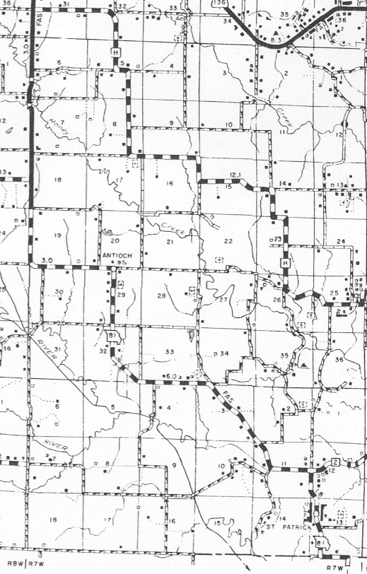
Jackson Township Map |
|
Jackson Township is made up of Section 1 through 36 Township 64 North Range 7 West, and Section 1 through 18 Township 63 North Range 7 West for a total of 54 square miles. |
Cemeteries
| Cemetery Name | Latitude D.d | Longitude D.d | Section |
|---|---|---|---|
| Day Cemetery Note: 2 | 40.313611N | -091.626667W | S26 T64N R7W |
| Llwellen Cemetery | S36 T64N R7W | ||
| Bash Cemetery | 40.309722N | -091.631944W | S26 T64N R7W |
| Dunbar Cemetery | S25 T64N R7W | ||
| Cemetery in section 12 Note: 1 | S12 | ||
| Tallman Cemetery | S15 T64N R7W | ||
| Antiock Cemetery | S29 T64N R7W | ||
| Smith Cemetery | S32 T64N R7W | ||
| Zion Cemetery | S13 T64N R7W | ||
| Evens Family Cemetery Note: 3 | S1 T?N R7W | ||
| St. Patrick Cemetery Note: 2 | 40.262778N | -091.624722W | S13 T63N R7W |
| Ellison Cemetery Note: 4 | 40.288611N | -091.632222W | S2 T63N R7W |
| Honey Creek Congregational Church Cemetery Note: 2 | 40.352778N | -091.683889W | S17 T64N R7W |
| Cemetery on Albert Boerner Farm | S17 T6?N R7W | ||
| Congill Cemetery | 40.297500N | -091.664167W | S3? T64N R7W |
| Jeffries Cemetery | S21 T64N R7W | ||
| Old Sisson Cemetery | S27 T64N R7W | ||
| Sisson Chapel Cemetery | 40327500N | -091.657500W | S22 T64N R7W |
| Mosely Cemetery | S28 T64N R7W | ||
| Kullick Family Cemetery | S13 T64N R7W | ||
| Resor or Hitt Cemetery | S3 T64N R7W | ||
| Mitts Cemetery Note: 2 | 40.319722N | -091.665556W | S23 T64N R7W |
| Walker Family Cemetery | S2 T64N R7W |
| Note: | Why |
|---|---|
|
1 |
"Cemetery Inscription of Clark County" list the cemetery on Brigg's Farm, and has two stone Wells d. 12/1817 -- Kurbay d. 3/1817 |
|
2 |
See http://www.mogenclark.org/clark/cemeteri.php for additional information. |
|
3 |
"Cemetery Inscription of Clark County" list the cemetery on old Ahern's Farm |
|
4 |
US Geographical Survey list this cemetery as Higbee Cemetery |
Populated Place
| City, Town or Village Name | Latitude D.d North to south | Longitude D.d east to west | Section |
|---|---|---|---|
| Antioch Note: 1 | 40.324722N | -091.693056W | S20/29 T64N R7W |
| St. Patrick Note: 2 | 40.264444N | -091.627777W | S13 T63N R7W |
| Winchester | 40.324722N | -091.611111W | S25 T64N R7W |
| Note: | Why |
|---|---|
|
1 |
Antioch is on the section line for section 20/29. |
|
2 |
Also known as North Santa Fm circa 1855 Map or North Santa Fe Was a settlement near the site of St Patrick per USGS-GNIS. Also known as Saint Marysville/Marysville |
Schools
| School | Latitude D.d North to south | Longitude D.d east to west | Section |
|---|---|---|---|
| Antioch | 40.317500N | -091.694167W | S20/29 T64N R7W |
This page last updated: Wednesday, September 17, 2014 10:18 |