 |
Ray County Genealogy Home Page |
 |
|
|
Ray County Genealogy Home Page |
|
|
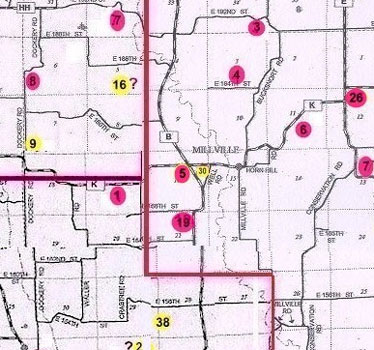
Millville Cemetery
|
||||||||
 |
||||||||
| Name of Cemetery | Millville Cemetery | |||||||
| Township | Grape Grove Twp | |||||||
| Cemetery # | #405 | |||||||
| Alternate Names | Millville Community Cemetery; Bransford Cemetery; John Taylor Young's (per Big Black Cemetery Binder) possibly Bullock Cemetery & Millville Cemetery are the same cemetery Death Certificate for Nimrod Wall indicates he was buried in Bransford Grave Yard. Millville Cemetery records lists Nimrod Wall |
|||||||
| Latitude/Longitude | Latitude: 39°24'15"N; Longitude: 93°56'5"W | |||||||
| Township/Range/Section |
T53R27S16; SW1/4 of NE1/4 |
|||||||
| Cemetery Still in Use | No | |||||||
| Size of Cemetery | about 75 known graves; probably many more | |||||||
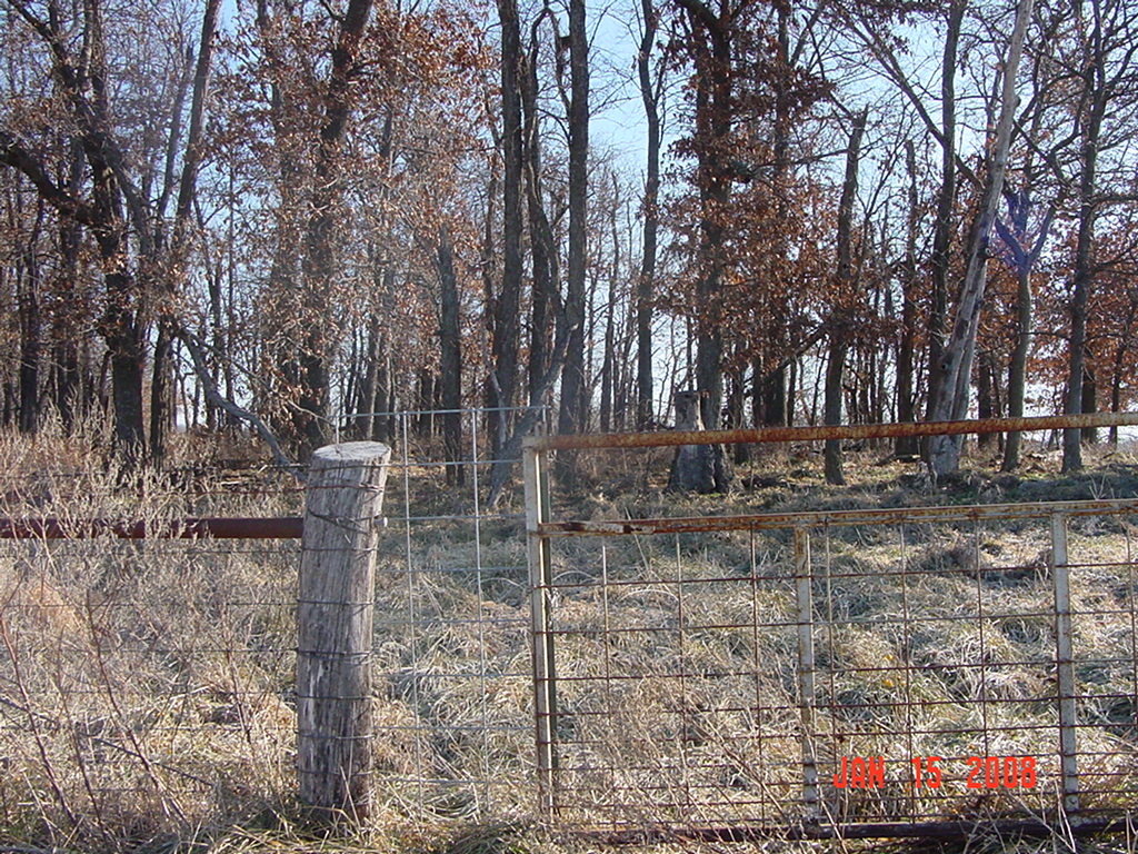
| Condition | most of the stones were tipped over; cemetery is fenced, but not maintained; fence on north side has been damaged by fallen trees | |||||||
| Range of Burial Dates | ||||||||
| Oldest Known Stone: | Jarman Winsott d. January 29, 1848 | |||||||
| Last Known Burial | Thomas McClain Stanley d. February 15, 1931 | |||||||
| Visited yet? | CC - yes................ JZ - yes/no...........anyone else - yes | |||||||
| Location/Directions/Comments | ||||||||
| Most recent directions | The cemetery is located on the southwest corner of Hwy B and Hwy K south of the deep ditch. From that intersection drive west on Hwy K about 1/10 mile. Park on the south side of the road near a gate. Walk thru the field over a shallow ditch to the gate of the cemetery. | |||||||
| 1973 Ray County History; p. 230 | not shown | |||||||
| 1973 Ray County History; p. 232; Cemeteries Not Listed on Map | not listed | |||||||
| Big Black Cemetery Binder | also known as John Taylor Young's | |||||||
| Cemeteries of Grape Grove Township by McKemy | From junction of Hwy B and Hwy K, go 300 yards southwest of corner; across ditch in grove of trees; on private property; in poor condition; fence down/cattle running in cemetery; about 73 marked graves (1994) | |||||||
|
Ancestry.com |
Located one mile west of Millville, Missouri |
|||||||
|
DAR Index: |
From junction of Hwys B and K, go 300 yards southwest of corner, 1 mile west of Millville |
|||||||
| LS info | xxx | |||||||
| Other Comments | xxx | |||||||
| Plat Maps | year | marked? | who's land? | |||||
| T53R27S16 | 1877 | no | Wild & Jones | |||||
|
1897 |
no | Wall & Linney | ||||||
| 1914 | yes | Bullock Bros. | ||||||
| 1930 | no | W. S. Bullock | ||||||
| 1970 | no | N. & W. A. Pulliam | ||||||
|
1976 |
no | N. & W. A. Pulliam | ||||||
| 1997 | no | Steven Pulliam | ||||||
| 2005 | no | Steven Pulliam | ||||||
| Transcriptions online: | ||||||||
| GTT online | ||||||||
| Ray County Archives | ||||||||
| Ancestry.com | ||||||||
| Find-A-Grave | ||||||||
| Other Online Link | ||||||||
| Compilations | Cemetery Records of Ray County, Missouri, Volume 1 - Antioch, Belt, Bethel, Little Union, Millville Community, New Hope, Penniston, Pleasant Hill, Smith, Tinney Grove cemeteries; Copied by Elizabeth Prather Ellsberry, Juliette L. Smith, and Mrs. Carlton Richardson; Published by: Elizabeth Prather Ellsberry; Box 206; Chillicothe, Missouri; Copied by Mrs. Carlton Richardson, Rayville, Missouri, December 1965
Cemeteries of Grape Grove Township, January 1995; compiled by Al McKemy, 26 Apr 1994 |
|||||||
| Library References | ||||||||
| Genealogical Library - Ray County Museum | ||||||||
| Ray County Library - Richmond | ||||||||
| Mid-Continent Library | MC 977.819 M195c AFRA | |||||||
| Family History Library (FHL) | FHL 977.819 V3e v. 1-2 | |||||||
| Lookups | ||||||||
| Ray County Cemetery Project Volunteers | ||||||||
To add additional information relating to Ray County, Missouri Genealogy, E-Mail the county coordinator.
Ray County Home Page | MoGenWeb | USGenWeb | WorldGenWeb | E-Mail County Coordinator
To add additional information relating to Ray County, Missouri Genealogy, E-Mail the county coordinator.
